Contact David McCutcheon:

Thursday 6 October 2011

iSad

I've been pretty slow to respond to the death of Steve Jobs today. It's taken me a while to come to terms with. After all, this man changed my life. Who else can I say that about? It's worth repeating. This guy changed my life. Here's why.

I came to the scary world of digital cartography very late - 1991. And I could have so easily missed the boat. Thanks to Malcolm Swanston and Swanston Publishing (early pioneers of DTP Cartography in the UK) I retrained. As I recall I first worked on an Apple Macintosh IIci, with a 40 megabyte hard drive. 

It sold for $6000. But it was a great machine. I could preview my work in colour! We were running Adobe Illustrator 3 and Freehand 3 on OS version 6, and later version 7. I did try using CorelDraw on Windows at that time, but the user experience was just not the same. I soon fell in love.


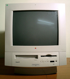
1989-1991 is sometimes called the first golden age for Apple, but it all went downhill from there. Innovative ideas, but performance was poor and under Gil Amelio's tenure things got worse. I bought a Performa for home use in the early 90's, and frankly it wasn't very good. 

 I ended up selling it to a mate. Apple's first PDA, the Newton, came out about the same time. Another financial failure - but it paved the way for the Palm, the iPhone and the iPad. The company were on it's knees by now. But there was still a spark of hope.


In 1997 Steve Jobs rejoined Apple. Let's call this day zero.
Remember him? He's the bloke who built the first Apple in his garage, later attached a mouse to it and re-invented the GUI. My facts may be wrong here - but hey, I'm an Evangelist, and that's what Evangelist's do!


In 1998 Apple launched the iMac. Holy Moly! Not a grey box, but curvy and cuddly. I bought a Bondi Blue RevB version and adored it. Within a year under Job's tenure Apple started to build the iLife suite. iMovie, iPhoto and Garageband soon became must-have consumer software. On the professional side, Final Cut Pro and Logic were added.

Things had been turned around and Apple are back in profit again, but what happens next is just, I dunno, amazing.

March 2001 saw Mac OS X released - a completely new architecture, and the transition was really smooth for me. How did they do that?
May 2001 - the first Apple store opens. Now there are 350.
November 2001 - 1st iPod goes on sale. OMG.
April 2003 - iTunes launched.
January 2006 - shift to Intel Macs.
January 2007 - iPhone launched. Another OMG.
July 2008 - App Store launched.
January 2010 - iPad launched. Yep, another one.

What a 10 years that was! The iPod is not yet 10 years old, and Jobs has changed the music industry forever. With the iPad publishing is going the same way. The mobile phone market has had to up it's game to match the iPhone.

I don't bow down to the altar of all things Apple - I have no iPhone or iPad, and my iPod is a £40 shuffle. But I adore my Mac. It's not my adversary. I treat it well and it returns the favour in being reliable, stable and dependable. It enables me to make a living, in a way that is an enjoyable interaction with technology. If only for that reason, thank you Steve Jobs.

Friday 30 September 2011

Competition time!

Just post the answer to this question on my Twitter page, @DVDMaps
Name one overseas country where I have lived and worked. Simples!

The prize is the best Cartography available in Charlbury, West Oxfordshire. (Well, the best north of Market Street. Apparently I'm not the only Cartographer in the Village)

Good luck.

David


Thursday 29 September 2011

Free Cartography - are you REALLY serious?

Despite a decidedly lukewarm response to my competition, I will honour my commitment, to mark 2 years of DVDMaps.

So here is how it works. As I have clients all over the world I will launch the competition at 22.00 GMT tomorrow. That should ensure you can enter if you are in the UK, USA, SA, India, or in NZ. If you are in Sydney or Melbourne, I'm sorry, you will just have to get up early.

So the prize is a whole days work, free of charge, on a project of your choosing. That's for an existing client. For a new client, the prize is half a days work. There are two prizes. What constitutes a whole day's work is negotiable!

I will post a question on Twitter and on this Blog tomorrow at 22.00 GMT, so simply be the first to answer correctly to win. The answer to the question will be on my Website. No other T&C's - you will just have to trust me!

To enter you will need to follow me on Twitter and post your answer there.


Good luck!
David


Tuesday 6 September 2011

Free Cartography - are you serious?

DVDMaps will be two years old very soon, and I have devised a competition to mark the day. Fabulous prizes! Free Cartography! Onerous T@C's!
To be in in with a chance of winning, you need to like my DVDMaps Facebook group, or follow this Blog or follow @DVDMaps on Twitter.
Competition details will be announced on 31st September.
So what are you waiting for?

Saturday 6 August 2011

Money well spent

I have just splashed some cash and bought the Times Concise Atlas to use as a reference. I contributed to this some years ago, but I expect very little of my work remains. Probably just as well! 

But what a wonderful product. I can guarantee this will never be further than an arm's length away.

It has already been used to check the location of an obscure National Park in Argentina.

Money well spent. Maybe one day I'll get a new Times Comprehensive. But until then...

Monday 11 July 2011

Welcome South Sudan

Revolutions, Civil Wars, Internecine fighting, Coups and the Arab Spring.

It's all pretty messy out there, and I can't help but feel it always will be. As a Cartographer I sometimes suggest that these are welcome developments, generating work to revise all of our maps. But it's a double-edged sword, as the cost to human life is often so high.

Add to that the potential for conflict caused by Global Warming, and you start to wonder what the future may hold.

So in these uncertain times lets wish the world's newest country - South Sudan - a stable and fruitful future.

Here's a new World Map for all you lazy Cartographers out there.

Saturday 18 June 2011

Eccentric Maps

Sometimes you come across maps in the most unexpected places. So let's start with a centrepiece of the Portland Rose festival, which closes tomorrow, 19 June 2011. Within the Pioneer Courthouse Square is a map of the world, set out in flowers. Each country of the world is represented using a particular flower. For instance, purple flowers for the United States of America, red for Mexico, and green for Japan. Very nice - so far. But what's this!
Japan is represented in green, bamboo-like plants. But to the south Taiwan has the same green plants. And to the North of Japan Sakhalin Island is green too. I expect the Russian and Chinese delegates to the Portland Rose Festival may have some reservations about the display. The flowers were corrected after a while, but apparently Sinai still belongs to Jordan. 
This started me thinking - someone should consider a thesis investigating why horticulturalists have a world view stuck in 1945. Thanks to Sarah Morrigan for the details.

Then I spotted an Estate Agents' car in Woodstock the other day. I always ensure that I have a map in the car before I go on a journey. But here is a better idea - have a map ON the car! Now if I forget my map, I'm always covered. The new Mini was completely covered with local maps, from the Ordnance Survey as far as I could tell. Despite inspecting the car from bumper to bumper, I failed to spot a copyright note.

And one more. Not so unexpected, this one. As a freebie to a local music festival I produce the site map for the programme. I was pleased to see it blown up to a 2 meter high poster at the site today, and I think it works quite well. Not entirely happy with it - I may need to refine it for Riverside 2012


I entered the site today and happened across an acquaintance of mine - a speculative property developer (you can choose your family...)
He was lost, and asked me where the bar was. On reflection, many hours later, I suspect he was teasing me. Or maybe I overestimate his intelligence...


Wednesday 18 May 2011

Giro d'Italia

I'm following the Giro d'Italia, but not with any great enthusiasm. It's a Grand Tour that a British rider has never won. That is not so unusual, as we've never won any Grand Tour. But The Giro has been won by Italians 66 times. I put this down to Italians feeling comfortable wearing a Pink Jersey (Maglia Rosa), whereas this colour does not sit comfortably on one of our own. I may be wrong.

Mum has been incensed this year at the course chosen by 'the men in blazers'. 

"They've never ridden a bike" she exclaimed to me. But the Giro tends to do this more than Le Tour, sending the riders up ridiculous inclines, often on gravel tracks to a mountain peak. It's a cruel race.

But I was concerned when on Sunday the Giro decided to enter Sicily. Mark Cavendish Tweeted:
"En route to Sicily. Ah, the nostalgia of boarding a ferry to a place full of gangsters. Reminds me of my teenage years going to Liverpool."

 The route took the riders up Mt. Etna. Once from the North and once from the South. Odd really, as the volcano had erupted only 4 days previously. The men in blazers did not see this as a problem. Race Director Angelo Zomegnan admitted that there may be some rocks on the road and a layer of ash, but was hopeful that his teams could clear the road come Sunday. "We are 'tranquil'," he added. 

Hang on - rocks on the road and a layer of ash - what is this, Giro Extreme Challenge?

So just to recap here. It is considered dangerous for a Jet Engine to fly through an ash cloud, but it's OK for a racing cyclist. Bizarre.

Thankfully the stage passed without incident. Except that the inner sanctum of the Pro Cycling teams' luxurious coaches is rarely breached. It is impossible for a film crew, a journalist or a fan to be allowed onto the bus. So how 247 Africans were intercepted when the Team Coaches left Messina remains a mystery. You have to hand it to them.

Thankfully every team and rider is issued with a Route Map of the race, so they can study the route. I'd love to get that job, making those maps. I really must pursue that avenue.


Monday should have been a rest day. But that was not always the plan. The men in blazers deemed that a stage in Africa would be a good idea. And why not? The Giro started in Greece in 1996, and will start in Denmark in 2012. So why not take the Giro to Africa? It's not a long way, and given the colonial ties between Italy and North Africa it probably seemed like a good idea at the time.

The stage identified was Misratah to Tripoli. Perfect distance at 215km (135miles) and good transport links with regular ferries and good air links. As Paris-Nice is known as 'The Race to the Sun', this historic stage was to have been 'The Race to muˈʕamːaru lqaðˈðaːfiː'. Catchy, eh?

But the routes for these Grand Tours are planned a year in advance, so who was to know how things would turn out? I don't have the original route map for this stage, but it looks pretty much like this at the moment. Such a shame. Maybe next year.


So Monday became a rest day after all. On Tuesday the men in blazers had a day off, sending the peloton north after an air transfer. The route zapped up the coast, the steepest incline being a speed bump. Cav went apoplectic on Twitter

"Look! Look! Oh! Oh! Oh! Look! Look! A sprint! A real sprint! For sprinters!"

And he duly won the stage, but not without controversy. Adversaries accused him of taking a tow from cars up Mt. Etna on Sunday. Ashen faced, Cav denied any wrong doing.

I never expected Cav to win the Green Jersey on the Giro. Because that's the Mountains Jersey - Maglia Verde. The Points Jersey is the Rosso Passione. Confusing isn't it.

Pancake flat again tomorrow, and then I expect the sprinters will call it a day before the weekend. 


And who can blame them. There's the Grossglockner on Friday, then the big one.

To quote The Daily Peloton
"Stage 14 is the kind of stage of which cycling fans the world over dream about.. Today is why grand tours are the most exciting spectacles the sport offers. The sort of day when history is made, legends are written and heroes made. And it's a Saturday which means the entire cycling world will be glued to their TVs or hunched over their PCs, if they are not on the slopes of Monte Zoncolon itself. The stage starts in Austria, in Lienz, before crossing back into Italy for four classified climbs en route to the Monster itself...
…after the Crostis comes the climb that strikes fear into the peloton, the brutal Monte Zoncolon. The climb is 10 km and includes a 5 km stretch that averages a leg killing 15% and has stretches that max at 22%. It is going to be horrible for the riders, but glorious for everyone else".


Gruesome. Mother will be cursing the men in blazers, but glued to Eurosport all day. Such is sport.

Thursday 7 April 2011

Website update

Home page
Finally my long overdue website update is now live. Many thanks to all those who have helped - Keith, Liezel, Greg, David and Aaron.

And I'm pretty happy with it. Tried and tested with various browsers and systems. Only IE6 messes it up, but I can live with that. If things don't work for you, do a refresh and check your browser preferences.

I'm especially proud of the work/gallery page. Considering I was cast into the dangerous waters of freelancing only 18 months ago, I don't think that's not a bad portfolio.

Onwards and upwards!

Friday 1 April 2011

Minimum Requirements

My First Lieutenant in CT recently brought this site to my attention, thinking it may be of interest. Indeed it is interesting, and I should maybe blog about it. But then just a few lines in I came across the fatal words - 'PC only'. And now I don't want to know.

So rather than blog about for all what I know may well be a ground breaking application, I'll do something else.

I was recently given a Sony EReader. I thought I may be able to use that - to read books and stuff. 'PC only'. I lost interest. It's a bit like not wanting to join a club which would have you as a member. If companies put out these sort of products then they are not talking to me.

As a Mac user I find this frustrating from time to time. I see it as being lazy and sloppy. Yes, I know - it's all about economics and your user base, but I still find it surprising how so many major initiatives and producers can be so short-sighted.

My allegiance to the Mac goes back 20 years now. I trained using traditional manual techniques, and almost missed the boat when it came to switching to digital. I had a lucky break, and despite my fear and ignorance of computers Malcolm Swanston took a chance on me as a freelancer and trained me up to make maps using Illustrator 3 and Freehand 3. Good times. Swanston Publishing did a lot of work for the 'Times Atlas of World History' at that time, and were instrumental in implementing new DTP technology into Cartography. We made some super Historical Atlases there, and my love for Macs was founded.

By this time, despite Apple's troubles, I was a Mac evangelist.

But Swanston Publishing folded, and I soon found myself in a much tougher commercial world. Where using PC's was a requirement. I stumbled around a couple of projects using Maplex and MapInfo, but was never comfortable in that environment. GIS just isn't my bag. Now I'm on my own, and content with that.

So I still use my Mac every day for work. My background and strengths are in graphics and publishing, and that is where my MacPro excels. That a Mac is female there is no doubt. A PC is male, and anything else is Gay/Bi/Trans.

Thinking of my domestic machines, my Performa was a kindly auntie. My Bondi Blue iMac was a mischievous niece. My eMac is a good sister. My G4 is a watchful Grandmother. And my G5 - it's like the daughter I never had.

It's not that I bow down to the altar that is Apple. I have no IPhone. I have no IPad. My IPod is a £30 shuffle. But I adore my Mac. She never fails me.

So that's where I am.

I don't need to know about your C:Drive
I don't need to know about your .exe files
I don't need to know about your right click
I don't need to know about your Norton, McAfee, or how many spams and viruses infect you
And most of all, I don't need or wan't to know about 'PC Only'

Rant over - my girl needs attention

Monday 14 February 2011

The Coen brothers - mapping America

The 80's was not a great decade for cinema as I recall. So many Hollywood blockbusters which did nothing for me at the time. 

But I did see Blood Simple on release in 1984, and the Coen Brothers have been on my radar ever since.

So to mark the occasion of True Grit being released in the UK, I thought I'd plot the locations of their films. 

A very American odyssey...

Tuesday 1 February 2011

London's growing up!


The UK has never done skyscrapers very well. 
In London sensitivity towards the local heritage, concerns over sight lines to St Paul's, the proximity to Heathrow and recent economic uncertainty have conspired to keep building heights in check. 
But that is now set to change, with a 'cluster' of new buildings either complete, under construction or planned for the City of London. 
The designs are generally quite restrained - this is not Dubai after all - and I'm generally in favour.
The Shard (whilst not within the Square Mile) leads the way - in more ways than one. I can't wait to see it completed - a must see London sight.
You can't fail to miss these landmark buildings in London, especially with the help of my handy spotters guide.

1 The Shard 305m
With the completion of it’s central core, The Shard has overtaken 1 Canada Square (Canary Wharf) as the UK’s tallest. The bottom third has already been clad in glass. It will be the highest building in Europe when complete in 2012 – at least for a while. Rival buildings for the European crown are mooted in Frankfurt, Moscow and La Defense. It is mixed use, comprising a hotel, residential, offices and a viewing gallery.

2 Bishopgate Tower (The Pinnacle, or Helter Skelter) 288m
Will be the tallest building in the City of London when complete, and Europe’s 2nd highest. Under construction - the core has reached the 9th floor.

3 The Heron Tower 230m
Recently topped out and due to open in February 2011. Currently the tallest building in the City of London. The design includes a Restaurant and Sky Bar at the top and a 70,000 litre aquarium in the reception area.

4 The Leadenhall Building (The Cheese Grater) 225m
This Richard Rogers design has had a stop-start history, with demolition of the previous building at 122 Leadenhall Street commencing back in 2006. However, construction started again in January 2011.

5 Tower 42 (formerly The National Westminster Tower) 183m
Arguably the first skyscraper in the UK by international standards, Tower 42 was the highest building in the City for 30 years, until the Heron Tower just over the road reached it’s 44th floor and overtook it in 2009.

6 30 St Mary Axe (The Gherkin) 180m
An iconic building, this Norman Foster design stands on the site of the former Baltic Exchange. It won a host of awards, including the 2004 RIBA Stirling Prize.

7 100 Bishopsgate 165m
Approved for construction, which should start in 2011 once the existing lease expires on the site.

8 Broadgate Tower 164m
At the northern end of the city, completed in 2009.

9 20 Fenchurch Street (The Walkie Talkie) 160m
The design of 20 Fenchurch Street divides opinion on a grand scale! The top-heavy appearance is driven by the higher rents that upper floors command – hence it’s bigger at the top. The groundwork is complete and work has started on the basement levels. Features 3 levels of ‘Sky Garden’ at the top.

Friday 28 January 2011

2David

Back in the day, I thought I knew a thing or two about using Illustrator. I started off with version 3.1, and reckon I knew about 80% of what Illy could do. Now, make that 40% or less. I learn on a 'needs-must' basis, but now am thinking I need to up my game.

This frailty came to light this week, when I was asked to produce some maps illustrating walks in Rome. The key word here may be 'Illustrating', as I'm not an Illustrator, I'm a Cartographer.

The maps feature a bird's eye view of a featured walk. A sort of 3-D effect. And this was my downfall. So many years of Topographic mapping has locked me into the 2-dimensional, and I can't visualise that 3rd dimension.

A shame really, as the finished articles look stunning when done well. I had a brief attempt at capturing these Roman streets, but soon realised that my ham-fisted attempts just don't do justice to the Eternal City. The task defeats me.

So now I'm thinking - what dimensions are open to me?

For now, I think it best that I be 2David, and consider my options.

At least that's better than being 1 dimensional.

Sunday 23 January 2011

I told you I could not draw...

But this was never an exercise in verisimilitude - more of a very personal recollection of a specific area, at a non-specific time.
The idea was to hand-draw a map of the streets around where I grew up, from memory without recourse to on-line resources or any tools other than a 99p set of crayons and any other pens/pencils I possessed.
Not all of the features shown were present at the same time. (The map covers a 15 year period)

What strikes me, looking back, is how this area (1km2 at most) managed to sustain 10 small corner shops and 5 Petrol Stations! I have not been back there for some years (it's a pretty grim town, to be honest), but I very much doubt that many of those establishments have survived.

I dare say much has changed in the area, but I don't plan to go back, check my map or update it. I have fond childhood memories of the area, and prefer to keep it that way. If there are any obvious errors, I'm sure my Mum will let me know!

Tuesday 18 January 2011

birdingwithpassion

Please support my good friend (and lapsed Cartographer) Martin Smith in his fund raising endeavors.

His mission is to log sightings of 100 birds within the boundaries of the City of Southampton, before Easter. All proceeds go towards staging a performance of the passion.

Martin is logging his sightings, and it makes fascinating reading.

Should he be stuck on 98 on Maunday Thursday, it is on my mind to bag a Pheasant and a Red Kite, drive down to Hampshire and release them in his garden!

Now only if I can persuade Martin to log all of his sightings on a map - I'd like to see that.


Saturday 15 January 2011

Hand Drawn Maps

Welcome to my new Blog. I know the layout is rubbish but I'm working on it...

This map recently caught my eye. It started me thinking of drawing a map on paper of around where I was brought up in Long Eaton - entirely from memory, without recourse to modern maps or any other reference.

Don't hold your breath as it may take a while - I can't draw!

What! Call yourself a Cartographer? Well, there's drawing and drawing, see?

Now where did I put my pencils and crayons? No, seriously, where are they?
adobe atlas bcs 3D blog british cartographic cartography cartographer consultant CS DVD Facebook flash freelance freehand gallery gis illustrator information interest internationally location map mapmakers mapping mx osm oxfordshire place-names plan publish research road satnav sitemap specialist street supplier tourism tourist travel twitter virtual wallmap web world terrain geography publishing
created at TagCrowd.com